Few words create panic for homebuyers faster than “flood zone.” Sometimes the concern comes from insurance costs. Sometimes it comes from lending requirements. And sometimes it comes from the assumption that a flood zone designation automatically means a property floods regularly.
That last part is where many buyers get confused.
FEMA flood maps are not predictions about whether a specific home will flood tomorrow. They are risk models based on elevation data, topography, drainage patterns, historical information, and projected flood behavior. Like any large-scale risk model, flood maps are periodically updated and refined as new data becomes available.
Which leads many property owners to ask an obvious question: Can you challenge a FEMA flood zone designation?
In some cases, yes. But most homeowners are surprised to learn that the process is less about arguing and more about documentation, elevation data, engineering, and formal review procedures.
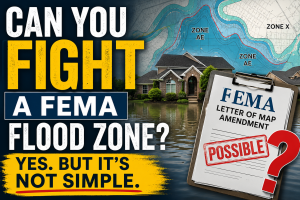
One of the most common situations involves homes that sit higher than the surrounding mapped floodplain. A property may technically fall within a FEMA-designated Special Flood Hazard Area even though the structure itself sits above the projected flood elevation. In those situations, a homeowner may be able to pursue what FEMA calls a Letter of Map Amendment, often referred to as a LOMA.
A LOMA is a formal FEMA determination that a structure or parcel was incorrectly included in the mapped flood zone based on elevation data. This is where things become more nuanced than many buyers expect. Flood zone designations apply to land, not just structures. One home may trigger lender-required flood insurance while another directly across the street may not. Small elevation changes, grading differences, drainage patterns, fill history, or updated surveys can create dramatically different outcomes between neighboring properties.
One of the reasons flood zones create so much confusion is that the boundaries can appear surprisingly precise. In some cases, neighboring homes can carry completely different designations based on elevation data and mapping lines that are difficult to interpret without reviewing the actual flood map. Buyers and homeowners who want to better understand how a property is currently mapped can review FEMA flood zone information using localized interactive flood map tools available for the St. Louis area. That inconsistency often surprises buyers, particularly in the St. Louis area where creeks, tributaries, and steep elevation changes intersect closely with established neighborhoods.
The challenge process itself is also widely misunderstood. Homeowners cannot simply call FEMA and argue that a designation “doesn’t make sense.” Typically, the process requires an elevation certificate prepared by a licensed surveyor or engineer showing the structure sits above the Base Flood Elevation. Additional surveys, engineering reports, and supporting documentation may also be required depending on the property and the nature of the request. Even then, success is not guaranteed.
Many flood-prone properties are accurately mapped and face legitimate risk during major rain events or river flooding. Others may qualify for amendments but still face lender or insurance complications during the review process. And importantly, removing a structure from a FEMA flood zone does not necessarily remove flood risk itself. That distinction matters.
One of the biggest misconceptions surrounding flood zones is the assumption that homes outside mapped flood areas never flood, while homes inside them always do. In reality, flooding can occur outside designated flood zones, and some properties within flood zones may never experience major flood damage at all. Flood maps are ultimately tools for measuring and managing risk. They are not guarantees.
For buyers and sellers, the practical impact can be significant. Flood zone designations can influence insurance costs, loan requirements, resale value, and buyer perception. For some buyers, the additional insurance cost alone can change affordability enough to affect purchasing decisions entirely.
At the same time, flood maps serve an important purpose. Lenders, insurers, municipalities, and emergency planners rely on them to make decisions involving infrastructure, development, and financial risk. That is part of why changing a designation requires more than frustration or disagreement. It requires evidence. And in a region like St. Louis, where waterways, older development patterns, and changing topography intersect closely with residential neighborhoods, understanding how FEMA flood zones actually work can make the difference between reacting emotionally to a map and understanding what the designation truly means.

Karen Moeller
STLKaren.com
Karen.McNeill@STLRE.com
314.678.7866
About the Author:
Karen Moeller is a St. Louis area REALTOR® with MORE, REALTORS® and a regular contributor to St. Louis Real Estate News, helping clients make informed, data-driven decisions.